

Meeting Documents
Exploring the Application of Image Super-Resolution Machine Learning Algorithms to Climate Data Downscaling.
Presented at: AGU Annual Meeting 2024
Abstract
The limited spatial resolution of GCMs hampers the study of critical physical processes such as precipitation in river basins and extreme typhoons, which severely hinders the assessment of the impact of climate events on local scales. This limitation may be addressed using newly developed super-resolution (SR) methods, which aim to reconstruct finer resolution data from coarser resolution data using machine learning (ML). However, a plethora of applicable algorithms have recently appeared in the literature, each claiming superior performance on standard image SR datasets.
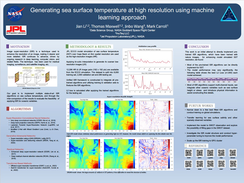
To evaluate the performance of various image SR algorithms when applied to climate data downscaling, we have developed an integrated SR framework to provide a common interface for the application of SR methods to various test datasets. We tested and ranked the performance of ten of the most promising image SR algorithms on a JPL ECCO model simulation of sea surface temperature (SST) over Cape Basin. The highest performing algorithms were then applied to a global scale SWOT SST observation dataset. Our investigation has demonstrated that image SR algorithms are a very promising approach to climate data downscaling.
The limited spatial resolution of GCMs hampers the study of critical physical processes such as precipitation in river basins and extreme typhoons, which severely hinders the assessment of the impact of climate events on local scales. This limitation may be addressed using newly developed super-resolution (SR) methods, which aim to reconstruct finer resolution data from coarser resolution data using machine learning (ML). However, a plethora of applicable algorithms have recently appeared in the literature, each claiming superior performance on standard image SR datasets.
To evaluate the performance of various image SR algorithms when applied to climate data downscaling, we have developed an integrated SR framework to provide a common interface for the application of SR methods to various test datasets. We tested and ranked the performance of ten of the most promising image SR algorithms on a JPL ECCO model simulation of sea surface temperature (SST) over Cape Basin. The highest performing algorithms were then applied to a global scale SWOT SST observation dataset. Our investigation has demonstrated that image SR algorithms are a very promising approach to climate data downscaling.